

On satellite and aerial imagery for free software
In our recent look at running a Google-free Android system, it was noted that the free-software mapping and routing application OsmAnd lacks support for using satellite photos as a background layer. OsmAnd is not unique in this limitation, of course; Navit lacks it as well, and it is an oft-cited issue in in-vehicle infotainment (IVI) discussions. Even the OpenStreetMap (OSM) community unsuccessfully attempted to build an open-source companion project using aerial imagery, eventually finding the task impractical. But the free-software community may be able to work around this obstacle by using other flavors of map data.
To recap, members of the OSM community launched an "OpenAerialMap" project in 2007, which ultimately ended up shutting down in 2008. The plan had been to merge several sources of freely licensed orthographic imagery, including satellite images and aerial photographs—the latter of which, in general, are the more useful option, since they are far less expensive (per-pixel) at any meaningfully high resolution. Aerial photographs are frequently available due to government land surveys and other research; airplanes can not only get better resolution than satellites, they are also better at collecting cloud-free images by flying lower.
The root cause of OpenAerialMap's shutdown was that raster images are simply far more difficult to work with on a global-scale map than are the vector-based maps that form the backbone of OSM. Many hundreds of terabytes of storage would be required to hold the images (images that compress far less than vector data even in those unpopulated regions with few roads), every image requires processing and alignment, and tremendous bandwidth would be needed to send it out to users as a map layer. Some day, perhaps, increased computing power and cheap connectivity may change all of the equations, but it was simply not a viable project.
Furthermore, even at the time, there were other freely-available (albeit not freely-licensed) aerial data options available for use with OSM: Yahoo agreed to let the project use its aerial-photo database as a background layer in the OSM map editor. The arrangement between Yahoo and OSM was discontinued in 2011—but, in its absence, OSM has an even better relationship with MapQuest. The company makes a "MapQuest Open Aerial Tiles" layer available for free to any application that credits MapQuest as the source and whose developers contact MapQuest if they think usage will exceed 4,000 tiles per second.
The MapQuest data is culled from US government sources, including NASA and the Department of Agriculture's (USDA) Farm Service Agency, so it would likely be the same as the images available to a project like OpenAerialMap. In addition, the USDA imagery is available directly from the US government, which has its own policy for attribution, thus making its terms of usage quite similar to MapQuest's.
Finally, although it might be wise from a software-freedom (and redundancy) standpoint for there to be more than one source for such data, as a practical matter, each end user tends to use aerial map layers in a transient fashion only. That is, the tiles directly under the current map or route are of interest, but caching them long term or storing them permanently does not add anything. Combine these factors together, then weigh them against the cost of running an aerial-data web service, and MapQuest Open Aerial Tiles have effectively nixed the desire for the community to run a competing service.
Alternative alternatives
On the other hand, it can also be instructive to consider what purpose an aerial photo layer serves in a mapping application. It is purely for the benefit of the user; all computation is performed on the vector layer (including finding routes and placing points of interest). To the user, an aerial data layer can assist in several ways. It can help the user better visualize the surrounding area and spot inconsistencies with the vector map, such as a road that leads directly into a lake. It can also provide a more realistic visualization of what lies ahead—showing buildings, hills and valleys, hazardous-looking sinkholes, and so forth.
The importance of the map-inconsistency case depends on how good the map is. OSM and other free-software mapping projects are very much of the "best effort" variety and, in theory, an inconsistency between OSM data and the real world will get spotted and corrected by OSM contributors. Thus, an aerial photo layer would be good, but it would also be a hedge against problems, rather than directly providing a necessary function.
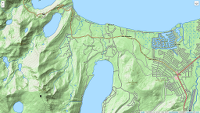
For the improved-realism case, though, OSM is proceeding on two separate fronts. The first is to create a more realistic rendering of the map terrain by using topographic relief data. The largest project here is TopOSM, which is based on bulk data-set imports from government agencies (many of which are the same agencies that provide aerial photography data).
As of right now, TopOSM is limited in coverage to the United States, but on the plus side, the TopOSM layer can render its elevation data in shaded relief that presents a quasi-3D view of the terrain. For simply getting a feel for what the surrounding countryside should look like, this makes it a fairly good substitute for an overhead photo. There are several other OSM-based efforts that focus on other regions, such as OpenTopoMap in Germany and Alpenkarte for the Alps.
The other front is visualizing buildings and other man-made structures. For this, OSM already supports the addition of 3D models. This, like all OSM sub-projects, is volunteer-driven, so 3D building coverage varies considerably from one place to another. Coverage in Germany is extensive; there is even a separate OSM-3D project (maintained by the University of Heidelberg) that focuses on providing a usable 3D map interface.
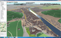
How useful a 3D model is for visualization also depends on its level of detail; on that front there is yet another OSM sub-project called—perhaps confusingly—OSM-4D that seeks to apply realistic textures to the 3D building and item objects in the OSM database.
Although it is not quite the same issue as aerial photography, the "Street View" function in Google Maps could be considered a related feature, since it, too, helps the user visualize the real world depicted in the map. Here again, OSM has a crowd-sourced project in the works that aims to fill the same niche. It looks to be in its early days, but there are also other ways to find geotagged photos associated with a location on the OSM map. Naturally, coverage in such a crowd-sourced project will be best near high-traffic spots like tourist sights.
There is always a chance that some as-yet-unforeseen development will suddenly make an OSM-like open database of aerial and satellite imagery a viable project. In that case, history suggests that the OSM community will not be slow to jump on the opportunity. In the meantime, though, it is interesting to see how the community has routed around the unavailability of such a free database.
Based on exploring TopOSM and OSM-3D in the
web browser, both projects certainly go a long way toward meeting the
needs of the user who is stuck without a satellite imagery option.
Perhaps the more pertinent question is why the various mapping
application projects have been slower to add support for these
alternatives. It may be that the incompleteness of the topographic
and 3D data sets makes for a less-than-inspiring map experience for
many users. Although, if that is the case, nothing seems to motivate
an OSM contributor quite like seeing a blank spot on the map.
The LWN site is currently under high scraper load, so comment display has been suppressed for anonymous users. If you are a human, you may read the comments by clicking the button below:
Note: you can avoid this step in the future by logging into your LWN account.